Map Editor User Guide - Navigation
|
Installation Feature LayerStyles Effects Drop Shadow |
This section describes the various ways of navigating around maps in Map Editor. Zooming
To fit the whole map into the window use the "Zoom to Fit" command. Panning
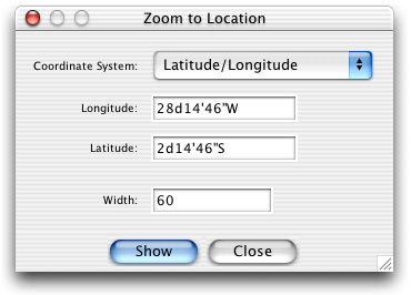
Changing the Centre of ProjectionThe Centre is only available when a map projection is being used. It changes the centre of projection to the point where you click. For example, if you are viewing the world with an Orthographic Azimuthal projection, what you see looks like a view of the Earth from space. Using the pan tool will simply move the globe around the screen. Clicking on a point with the Centre tool will change the projection centre to thtat point, effectively rotating the globe so that you are looking directly at the point. The effect may be different with other projections. For example, cylindrical projections will ignore the centre latitude but will honour the longitude centre. You can also change the centre of projection in the "Set Projection" dialog. Zooming to a Location
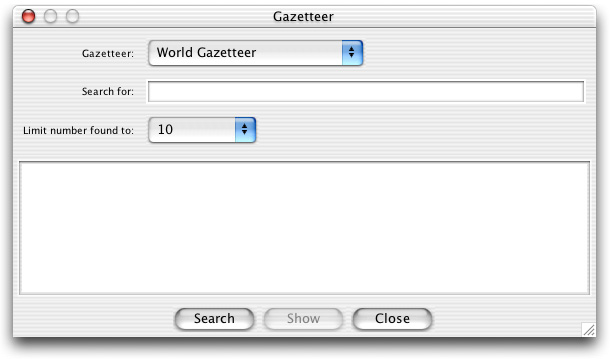
The "Zoom to Location" Dialog Using the Overview MapIf you have an overview map defined, you will see your current view as a grey rectangle in the overview window. You can drag this rectangle in order to change your view. Using a GazetteerMap Editor provides a gazetteer function which lets you quickly search for features and zoom to them. Selecting the "Gazetteer" menu item from the View menu displays the gazetteer dialog. Choose a gazetteer to search from the drop down list, type a search string into the text field and press the "Query" button. Any matches from the gazetteer will be displayed in the list below. You can select an item from the list and press the "Show" button to zoom the view to the item.
The Gazetteer dialog Various types of gazetteer are available such as text file, database or your own plugin. These allow you to create your own gazetteers from data you have. |